K-Maps
- Solution
- K-Maps
The only high-performance enterprise GIS server software in Korea which supports multiple spatial information service
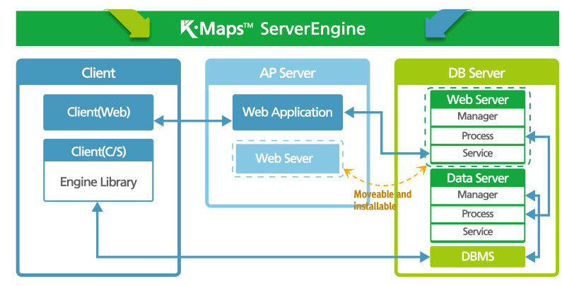
Server structure
KMaps Server
- A multi-purpose server for management, display, analysis, and service of GIS related spatial and non-spatial data - Engine
Composer
- A supporting tool for server monitoring, configuration setting, data construction, viewing, thematic map setting - Tool
SDK
- A developer tool designed to support development of server-based application programs - Toolkit
Open API
- A developer tool which supports development of web-based application programs and services - Toolkit
Manual
- Installation (system settings), administrator and developer manual - Document
Server Characteristics
Compliant with standard regulations and specifications
- Supports OGC (Open Geospatial Consortium) standard specifications and services
- Simple Feature, Coverage, GML, SLD, Filter, SE
- WMS, WFS(T), WCS, WPS
- Supports the international standard coordinate system and customized user coordinate system
- EPSG, SR-ORG
- OGC
- ISO
- EPSG
- SR-ORG
Multiple-integrated service
- One server is used to integrate the Socket, HTTP services in an integrated manner
- Various thematic maps can be serviced in one server
- National spatial information, underground facility integration, urban planning information, municipal organizations’ intranet, and facility management system
- The meta-information of the service is operated separately to minimize the impact on other services
- Server & Service
- Multi service
- MetaData
Standard system development & related support
- We develop standard system that can be operated in various platforms
- Compatible with all platforms where Jre can be installed
- We support various DBMSs used in the Korean market
- Oracle, MySQL, SQLServer, DB2
- Kairos, Altibase, Tibero, Cubrid, PostgreSQL
- Windows
- Linux
- Unix
- DBMS
Mass-storage & high-performance processing capacity
- We implement the most appropriate threading method for fast processing of large storage spatial data
- We develop various formats to enable various spatial data services
- Large-storage/capacity
- High-performance
- Web App
- C/S App
Server main features
| Distinction | Major functions | Note |
|---|---|---|
| System operation | Log-in/log-out, service management, log management, operational manipulation and monitoring | |
| Layer management | Creating, deleting, and editing layers, and management, locking, and unlocking of meta-information and schema | |
| Map management | Service map management, style management, symbol management, map coordinate system definition, and image map | |
| Coordinate system management | Referent coordinate system management, oval and transparency method management, transferring definition format, and coordinate transfer | |
| Viewing and calculation | Viewing property and spatial information, logic and spatial filter, spatial calculation, spatial relations, and surveying | |
| Data editing | Locking spatial information, managing transactional information, property and spatial editing, division, merge, and expansion | |
| Data conversion | WKT/WKB conversion, GML conversion, Vector and Raster file conversion | |
| Tools | Spatial statistics, tile map construction, terrain/space/Raster analysis |